
Salt marshes
Zeeland is water and land and… something in between. There are salt marshes and mud flats on the edges of the land. It is as if Zeeland has no idea where it actually ends. The mud flats are flooded every day. The salt marshes are a little higher, but there are tidal streams that run through them (sometimes quite deep) and these areas can also be flooded, especially at high tide.
Salt marsh areas
When the first modern people arrived in Zeeland after the Neanderthals, it was still predominantly an area full of salt marshes. At first, the new inhabitants were primarily hunters and gatherers, but they also made the transition to agriculture. Many traces of them have been found on Saeftinghe.
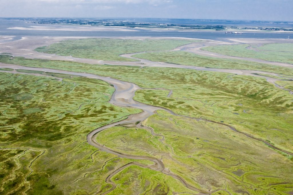
Aerial photo of the Drowned Land of Saeftinghe (Image bank Rijkswaterstaat, photo Joop van Houdt).
Archaeological discoveries in Saeftinghe
At the Verdronken Land van Saeftinghe (with 3,500 hectares the largest brackish water salt marsh in Europe) you get a good impression of what Zeeland must have looked like in those days. Around 1200, the area was almost completely reclaimed, but during the Eighty Years’ War it was flooded for military purposes. Nowadays, it is a protected nature reserve with several archaeological sites. For example, pottery shards dating back to the fourth millennium BC have been found there. This is the oldest evidence of agriculture in Zeeland. Flint artefacts and charcoal are still being found here (especially where the scouring effect of the water exposes new layers).
Visiting Saeftinghe
Not all of Saeftinghe is open to the public, but there are several routes through the salt marsh area that take you over ramps and bridges past imposing gullies and unique flora and fauna. You can walk here on your own – except during spring tides. If you prefer a more adventurous outing, you can also join an excursion organised by Het Zeeuwse Landschap (the organisation for the preservation of the Zeeland landscape). Then you get to wade through deep gullies and be told all about the animals and plants you meet along the way. We can guarantee that you will get mud on your clothes! Be sure to visit the Saeftinghe Visitors’ Centre, which is located right on the dike in Nieuw Namen. This is where you can learn all about the nature, landscape and rich history of the Land van Saeftinghe.
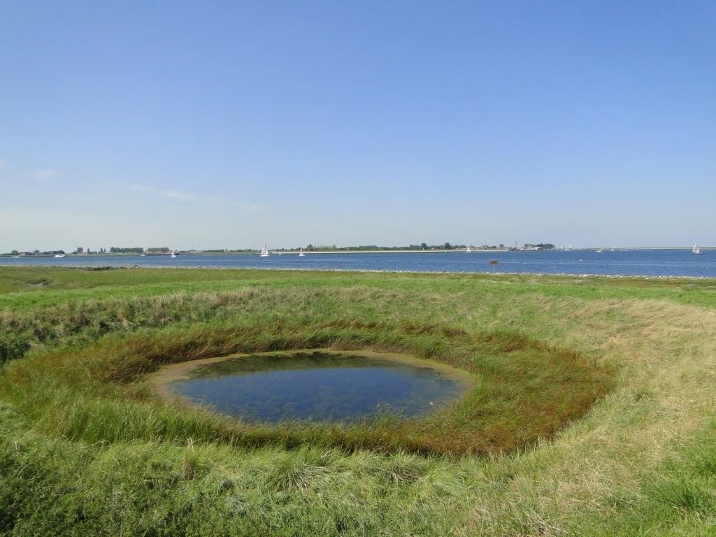
Hollestelle on the Rumoirtschorren (photo by Het Zeeuwse Landschap).
Grenspark Groot Saeftinghe
Grenspark (cross-border park) Groot Saeftinghe is a tidal area of 4700 hectares located on the border between the Netherlands and Belgium. The central focus is on the interaction between nature, agriculture, and the port. Grenspark Groot Saeftinghe is a collaboration between Dutch and Flemish partners and began in 2016 as a project aimed at providing the region with an ecological, economic, and social boost.
Stellen and hollestellen
Salt marshes (such as Saeftinghe, but also the Rumoirtschorren near Sint-Philipsland) were mainly used for herding sheep. Usually, the salt marshes would not completely flood during high tide, but it was of vital importance in this area to have a number of higher areas to be able to retreat to. That is why ‘stellen’, as in ‘mounds’ were built: small man-made hills where the shepherd and his sheep could sit out the tide. The shepherds (and their sheep) also needed drinking water. But it was not possible to dig a well on the salt marshes to provide this – at best, this would only yield salt water. So the shepherds built their own drinking holes. They dug a pit on the mound. This was used to collect rainwater and a drinking water reservoir was created that way. Because the mound was actually a hole in the groud thanks to the pit, these mounds were then called ‘hollestelle’, as in ‘hollow mound.’ A few hundred Zeelanders still bear this surname. The very last hollestelle in Zeeland can be found on the Rumoirtschorren (salt marshes) outside the dikes. What makes it even more special is that this hollestelle, which has been there for hundreds of years, still has fresh water. You can also visit the Rumoirtschorren on an excursion organised by Het Zeeuwse Landschap.